Hovlandsnuten and Etlådnefjellet (31.05.2020)

| Start point | Tveitneset (20m) |
|---|---|
| Endpoint | Tveitneset (20m) |
| Characteristic | Hike |
| Duration | 5h 15min |
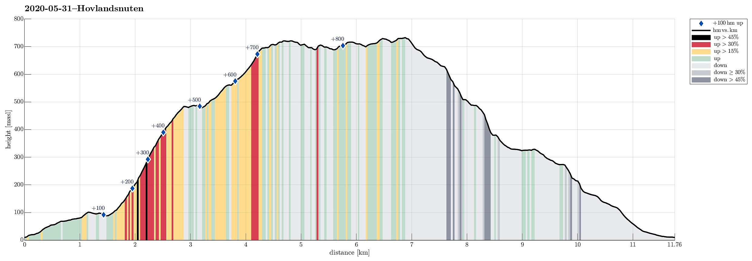
| Distance | 11.8km |
| Vertical meters | 888m |
| GPS |
|
| Ascents | Etlådnefjellet (737m) | 31.05.2020 |
|---|---|---|
| Etlådnefjellet, SV (737m) | 31.05.2020 | |
| Hovlandsnuten (727m) | 31.05.2020 | |
| Visits of other PBEs | Sjonarhaug (490m) | 31.05.2020 |
Trip Summary
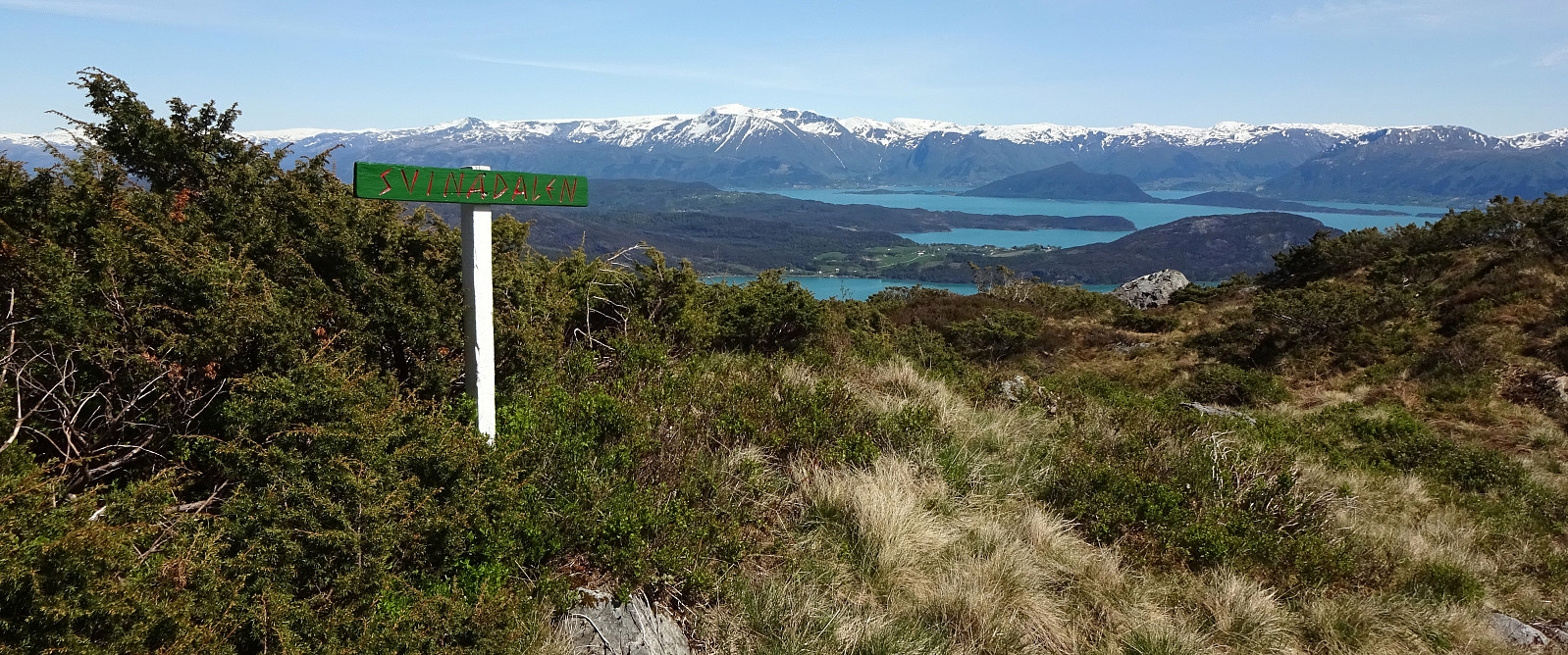
For years, we had talked about "one day" visiting Tysnes and doing some nice hike there. This weekend, with warm and sunny weather, seemed to be perfect to actually do it! :-) We drove from Bergen to Halhjem (southwest of Osøyro) and took the ferry to Vågen from there. Already this crossing of Bjørnafjorden was nice, with nice views towards south and east! Once on Tysnes, we drove first east (towards Lundegrend). There, we turned right (and south) and crossed over to the southeastern side of Tysnes (Hovland & Tveit). Our plan was to go a nice round over Hovlandsnuten, maybe the most spectacular mountain on Tysnes (not the hightest though). We parked near Tveitneset and started to hike along a forest road that extends southwards (parallel to the steep mountain side there, as well as parallel to the "main road"). After a bit of pleasant walking, we arrived in Li (Lie), where the actual ascent to Hovlandsnuten starts. Without any difficulties we were able to locate the trail-head right behind the "last building" north of Lie (on the eastern side of Liaelva, but not far from it). This trail leads then steeply upwards, staying on the eastern side of Liaelva (but close). The trail was not everywhere completely easy to find, but at large it was easy to follow. West of Hanarhaug, the trail passes a short stretch, where lots of tall trees were blown over some time ago. Fortunately, someone made a major effort to cut through these trees so that following the trail is no problem at all! At about 380mosl, just a bit east of Liabrekka, the trail splits (with the "main route to Hovlandsnuten" forking off to the right, in northeastern direction). At about 480mosl, just shortly before entering Svinadalen, on gets the chance to make a short detour to Sjonarhaug, a place with breath-taking views over the Fjord further south! After enjoying the views from Sjonarhaug, we continued our hike towards Hovlandsnuten (in northern direction). At about 515mosl, we passed by some nicely placed buildings (a privat cabin by now?), entering Svinadalen (from below). From there, it's the straight-forward (up through Svinadalen) to the main saddle west of Hovlandsnuten (at about 685mosl). Once on this saddle, it's then just a short and pleasant ridge walk over to Hovlandsnuten. Due to its very steep northern, eastern, and southern sides, Hovlandsnuten offers breath-taking views in all directions; truly amazing! Enjoying this top for a while, even having some nice little picnic there, we took our time before continuing. Our default plan was to descend from Hovlandsnuten in northern direction through Sandlopsdalen. Since the day was so nice, we decided to include Etlådnefjellet, also. So we walked back to the saddle above Svinadalen. There, we continued in western direction, crossing over some gentle heights between Hovlandsnuten and Etlådnefjellet. At Etlådnefjellet, we ascended to the few tops that seemed to stands out a bit more, enjoying some further nice views from there. At last, we ended up right at the antenna on Etlådnefjellet that is well visible from many directions. From there, we then descended in northern direction across Sandlopefjellet. A sequence of poles, marking the line where some cables (up to the antenna) were buried, lead us the way (at least on the upper part of Sandlopefjellet). Once down to about 620mosl, the terrain gets a bit steeper and one needs to watch one's steps. Once down about 100 heights meters from there, it gets less steep again; at least when heading towards the trail near Heiavatnet. Before actually getting to Heiavatnet, one finds the east-west going trail. Taking this trail further down (in eastern direction, towards Vasstøltjørna) is recommended as this side of the mountain (the northeastern side of Sandlopefjellet) is quite steep. At about 380mosl, the trail flattens out, again, and one approaches Vasstøltjørna without any further challenges. We spent a few minutes at the very refreshing Vasstøltjørna, before continuing further. In the southeastern "corner" of Vasstøltjørna, we needed to spot the right place, where a minor trail forks off the main trail (to the right, in eastern direction). While the main trail (a gravel road?) leads down to a parking lot on the northern side of the stream, which runs down from Vasstøltjørna, we had planned to take this minor trail, descending "in parallel", but on the southern side of the same valley, in order to get to another trail, which leads southwards (in the east of Hovlandsnuten, but west of the street further down). Coming by Galtakleivhaugen, we enjoyed this minor trail very much, bringing us almost perfectly back to our car (without the need to walk for a long distance on the "main road"). Just at the very end, we walked for a few hundreds of meters along Hovlandsstrando (with nice views over the near fjord!). All in all, this hike was really wonderful and can be highly recommended!
Photos
Selected photos are available as Google photo album.
Useful Resources
See also the related FB-page Hiking around Bergen, Norway.
Web page WestCoastPeaks.com provides useful information about Etlådnefjellet (Etlåndefjellet) and Hovlandsnuten.
Web page UT.no from the Norwegian Trekking Association recommends a similar hike (in the other direction).

User comments