Høgstefjellet and Veten i Åsane (25.04.2020)

| Startpunkt | Dalavegen (95m) |
|---|---|
| Endpunkt | Dalavegen (95m) |
| Tourcharakter | Wanderung |
| Tourlänge | 4h 00min |
| Entfernung | 9,2km |
| Höhenmeter | 756m |
| GPS |
|
| Besteigungen | Høgstefjellet (464m) | 25.04.2020 |
|---|---|---|
| Midtfjellet i Åsane (430m) | 25.04.2020 | |
| Vardfjellet i Åsane (355m) | 25.04.2020 | |
| Veten i Åsane (486m) | 25.04.2020 |
Trip Summary
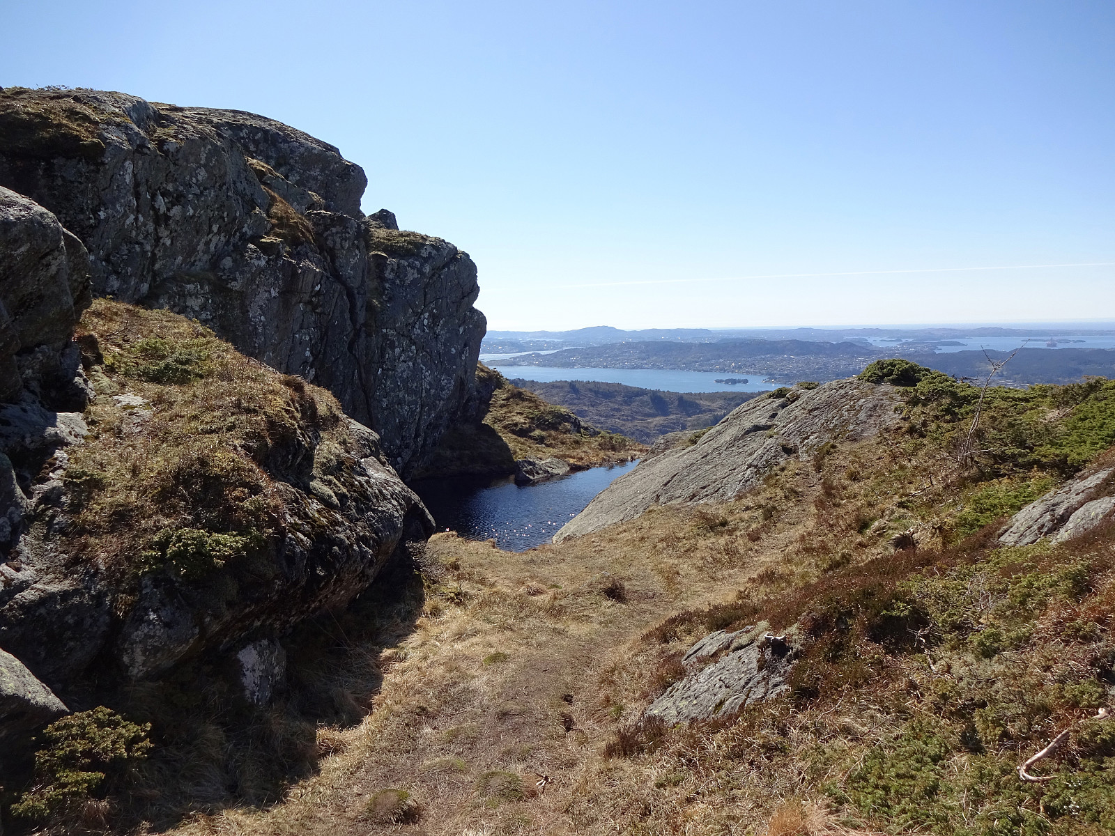
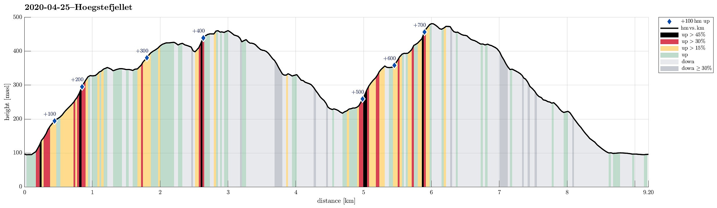
With a nice day ahead of us (but limited time), we decided to try a hike that we had thought about for a longer time already: combining Høgstefjellet and Veten i Åsane -- a plan not without challenges (Norgeskart does not show any trail that would connect the saddle between Høgstefjellet and Tellevikafjellet and Postvegen in the valley)! In order to start with Høgstefjellet, we parked along Dalavegen on the western side of Langavatnet. The idea was to ascend towards the ridge that leads up to Varden (in the south of Høgstefjellet). Within a few minutes, we had come to a nice ridge (above Linosa), ascending steeply from its eastern side. We knew that a bit further westwards a trail was marked on the map, but we thought that we could equally well ascend along the ridge as long as this was nicely possible (before connecting to the trail). Stepping up there was really nice (but without a trail), then! Once above 200mosl, however, we came closer to some thick looking forest ahead of us. Assuming that the trail is close (in the west), we headed diagonally into western direction (just to learn that the trail was not that close). "Eventually", we made it up to about 325mosl before connecting to the trail, enjoying some very nice views southwards (across Åsane and towards Bergen). We then crossed Varden and headed further towards Midtfjellet, which we wished to include before ascending to Høgstefjellet. While the main trails around there do not include Midtfjellet, it's worth the short detour, offering some nice views across Baugtveit in the north. Høgstefjellet is quite steep in its southwest -- thus we connected to the trail first before then stepping up to Høgstefjellet. This mountain, even though not very high, offers really nice views in all directions -- especially on a nice day, it's really worth the ascent (easy from Åsane). From Høgstefjellet, we followed our original plan to find a connection to Postvegen from nearby the saddle towards Tellevikafjellet. We descended the nice northeastern ridge of Høgstefjellet until we came to about 375mosl. There a little, muddy trail separated towards the east (down towards Langedalen). Descending there, and turning back into southeastern direction -- the right one! --, we started to believe that in fact we had found a reasonably good trail (that's not marked on the map). After a only a short stretch in the right direction, however, the trail turned left (northwards), again. Instead of trying to descend through the forest without a trail, we followed the trail, expecting that it would bring us down to Postvegen a bit further north. Once down to about 300mosl, we turned right at a trail fork, descending towards Gråberget through the forest (after a while there wasn't much of a trail left in this direction). Still, it was straight-forward and no problem to get down to Gråberget there. We rounded the horse farm at the bottom of Gråberget and connected with Postvegen from there. Instead of following Postvegen, however, we thought that it is nicer to ascend towards Veten across Olsrinden (the ridge east of Postvegen there). Instead of heading further north in order to get onto that ridge, we thought that "just bridging" the short distance up to the ridge "directly" from Postvegen should be possible, as well. Now that we have done it, we know, of course, that it's possible, but most likely we would not recommend this "shortcut" through the bushes up there (a bit steep, also). Much more comfortable, obviously, is first following Postvegen some 400m furthr north, where the ridge trail across Olsrinden starts. Once on Olsrinden, however, it was really nice to ascend up to Veten (and a bit of an exercise as this trail is not non-steep). Shortly after, we arrived at Veten, continuing more or less instantly further towards the south (and across its nice ridge). At Raudnipa, then, we sat down to enjoy a slice of bread with a lovely view towards the south (all the way to Gullfjellet). We then started our hike back, following the southern ridge of Veten further. South of Håkeberget, we took the trail towards Haukebotn, leaving the main ridge there. Rounding Haukebotn (on its south -- with nice views down to Langavatnet and Åsane), we connected to Rimmane. We then following this little extra-ridge (in the middle of the valley) down southwards before getting to Postvegen on its last stretch down towards Langavatnet. Once on Dalavegen, it was then easy and quick to walk back to the car. All in all, it was wonderful to cross both Høgstefjellet and Veten on such a nice day. Selected stretches of this hike, however, were a tiny little bit wilder than what one absolutely needs. In that sense, one can certainly improve on the choice of the route details.
Photos
Selected photos are available as Google photo album.
Useful Resources
See also the related FB-page Hiking around Bergen, Norway.
Petter Bjørstad has a useful page about Høgstefjellet and another one about Veten i Åsane, and also web page WestCoastPeaks.com provides useful information about Håstefjellet (Høgstefjellet), Tellevikafjellet, and Nordgardsfjellet as well as about Veten i Åsane.

Benutzerkommentare