Stangfjellet and Vedafjellet (19.04.2020)

| Startsted | Gjerdstad (60moh) |
|---|---|
| Sluttsted | Gjerdstad (60moh) |
| Turtype | Fottur |
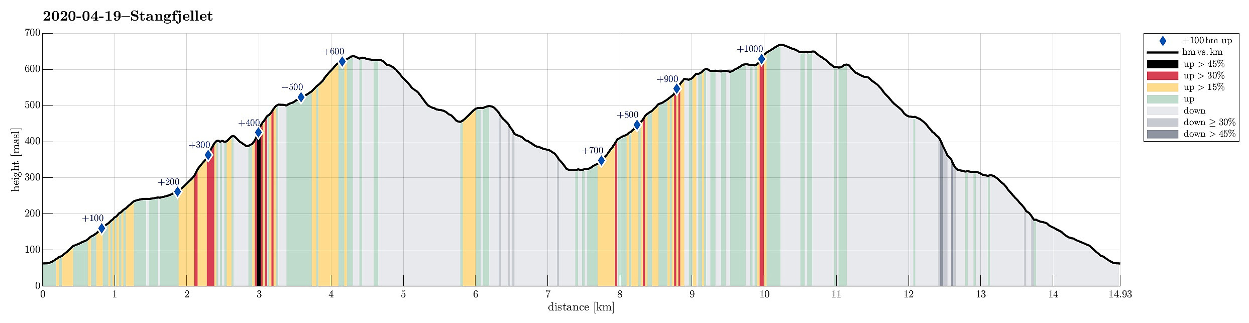
| Turlengde | 5t 30min |
| Distanse | 14,9km |
| Høydemeter | 1065m |
| GPS |
|
| Bestigninger | Bukkshovden (421moh) | 19.04.2020 |
|---|---|---|
| Innsetberget (505moh) | 19.04.2020 | |
| Setevarden (636moh) | 19.04.2020 | |
| Stongfjellet (640moh) | 19.04.2020 | |
| Vedafjellet (673moh) | 19.04.2020 | |
| Andre besøkte PBE'er | Hovdavegen parkering (259moh) | 19.04.2020 |
Trip Summary
With a nice day ahead of us, we decided to try a hiking round, which we had looked at already repeatedly over several years, including Stangfjellet and Vedafjellet on Osterøy. After some consideration of the available time, etc., we decided to start from Gjerdstad. After leaving E16 for the bridge to Osterøy, we crossed over and used the tunnel on the other side (into the direction of Lonevåg). Following street 566 further upwards, we turned right near Rolland, continuing on Gjerdstadvegen. After some 5km, or so, we came to Gjerdstad, seeing the church there prominently on the right side. Turning right and crossing the stream using the narrow bridge there, we were right at the church and parked there. Before even starting our hike, we first looked at a large memorial stone, opposide of the church, which reminds of the wars involving Napoleon and men from Norway (on the side of Denmark, back then). We then started our hike in southeastern direction, heading towards Rishaugen. Following a gravel road (upwards), we took a few correct turns, staying on the northern side of Gjerdstadfossen and ascending Rishaugen and Gråberget on their southern side (in eastern direction). This brought us up to Hovdavegen, already some 180hm higher than the church of Gjerdstad. The default from there would have been to continue first northwards in order to find the main trail up to Stangfjellet. Instead, we decided that we could also include Bukkshovden; not at the least as it was nicely visible from Hovdo! :-)
Bukkshovden
So instead of northwards, we headed southwards, following the gravel road that passes by Hovdo there. Instead of crossing the stream (as the main trail towards Vatnaleitet does), we continued on the gravel road, which quickly becomes very steep, ascending to a small saddle in the southwest of Bukkshovden. From there, it was then straight-forward (and easy) to ascend to Bukkshovden, even without any trail. Almost more interesting than the actual "top" of Bukkshovden is a little side-"top" in the west of Bukkshovden with a rather larger construction on top of it (something helping with navigation?). After enjoying some really nice views from there, we continued, crossing the actual "top" of Bukkshovden, and descending (the few meters) into Turdalen on its northeastern side.
Stangfjellet
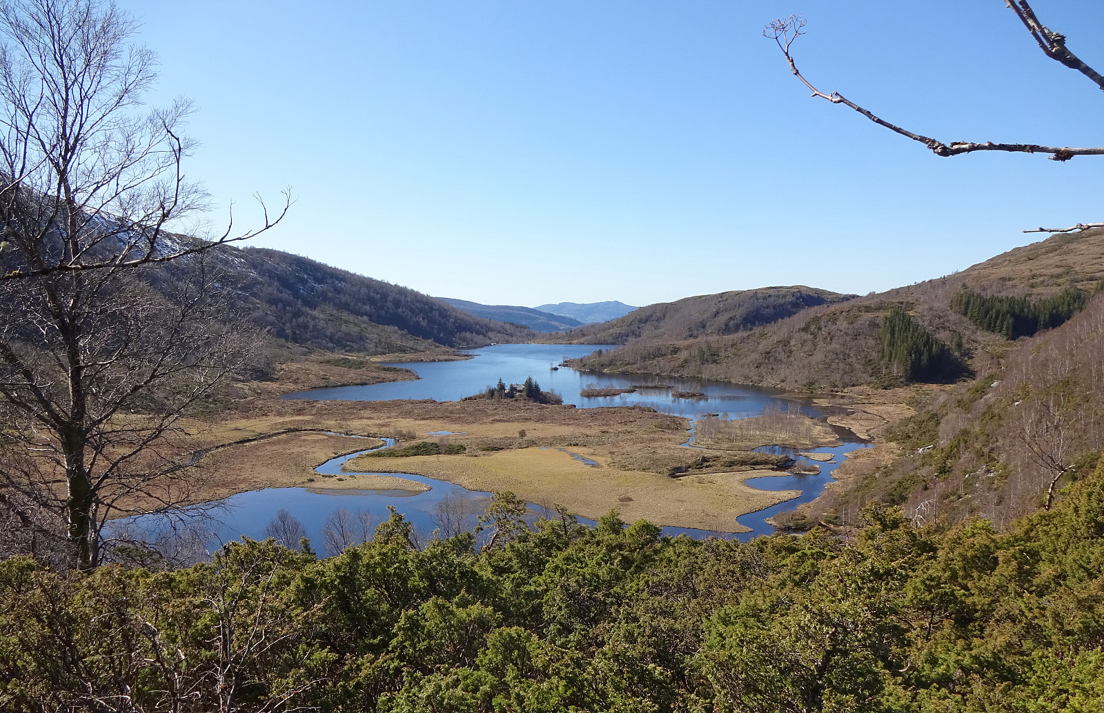
This way, one could say, we had eventually started our ascent to Stangfjellet (but from the southwest instead of using the main trail over its western flank). Instead of following the trail that follows Turdalen and continues towards Gamlestølen and Geitrheimssetret in the south of Stangfjellet, we decided to ascend directly upwards (quite steep, but fun!). Shortly after, we arrived at a little "nose" (at about 500mosl) from where we could enjoy some nice views, mostly southwards. From there, we then followed a nice trail to the top of Stangjellet. Instead of staying at the top (social distancing etc.), we immediately crossed over it, checking the view towards the north on the others side (great!) and then turning into southeastern direction (into the direction of Innsetberget). All in all, Stangfjellet is really worth an ascent. Even though not really very high, it offers great views in all directions. Recommended!
Innsetberget
Following a nice trail downwards from Stangfjellet (in southeastern direction, towards Geitrheimssetret), we soon came to the saddle, where the trail from Turdalen crosses over. Crossing the saddle (and this trail), we ascended to Innsetberget on the other, southern side. Innsetberget is really not anything like a prominent mountain, "sitting" in the middle of higher mountains all around it, but still it is really nice to do the short hike up there. The views down to Storavatnet (and Sildatjørna) and further to Vedafjellet and back to Stangfjellet are really very nice!
Vedafjellet
Crossing over Innsetberget (and enjoying a small snack in a lovely sunny spot not far underneath the "top"), we headed towards Vokhaugane and the bridge (over Tverrelven) in the southwest of them. Even though this trail is steep, it's certainly no problem (especially in nice weather). After crossing Tverrelven near Revheimssætra we started our ascent towards Vedafjellet (by first heading towards Vindegga across Heggelia). Being protected from any mentionable winds down there, we were heated up by the sun as we ascended to Vindegga, enjoying there, first and foremost, the little wind that welcome us on the saddle! :-) From Vindegga, we then turned right (and in southwestern direction) to continue towards Vedafjellet. This way, one first crosses a non-short ridge, including Varden and Gallnanipa along the way, before getting up to some usually swampy heights north of Djupedalen. This time, however, a mentionable amount of snow covered all water up there, making progress straight-forward into the direction of Vedafjellet. Crossing (again) under the power line, we made the final ascent to Vedafjellet. While we crossed quite a bit of snow doing so, all this was easy and straight-forward. Especially given the very nice day with sunshine and pleasant temperatures!
Back to Gjerdstad
From Vedafjellet, we then started our walk back to Gjerdstad, descending via Setevarden and Vedaflærne. This gentle and nicely marked trail (not utterly much used, but very easy to find) brings one down to Vatnaleitet near Litlavatnet. From there, the main trail leads to Hovdo (where we had been earlier this day). Instead we found the right turn (to the left, towards west) only a bit after descending from Vatnaleitet, leading us onto a nice trail that heads "diagonally" downwards to Gjerdstad (via Bjoamyra). Almost back down in Gjerdstad we crossed over Gjerdstadfossen to connect back to the gravel road, which had used already in the beginning of this hike. Arriving in Gjerdstad, we were highly satisfied with this wonderful hike (in perfect weather!). Stangfjellet and also the whole round including Vedafjellet can be strongly recommended!
Photos
Selected photos are available as Google photo album.
Useful Resources
See also the related FB-page Hiking around Bergen, Norway.
Petter Bjørstad has a useful page about Stongfjellet and also web page WestCoastPeaks.com provides useful information about Stangfjellet.
Web page UT.no from the Norwegian Trekking Association recommends another hike over Stongfjellet (without Vedafjellet).

Kommentarer