Grånipa and Gløvreegga from Vaksdal (19.05.2019)

| Start point | Vaksdal (40m) |
|---|---|
| Endpoint | Vaksdal (40m) |
| Characteristic | Hillwalk |
| Duration | 5h 30min |
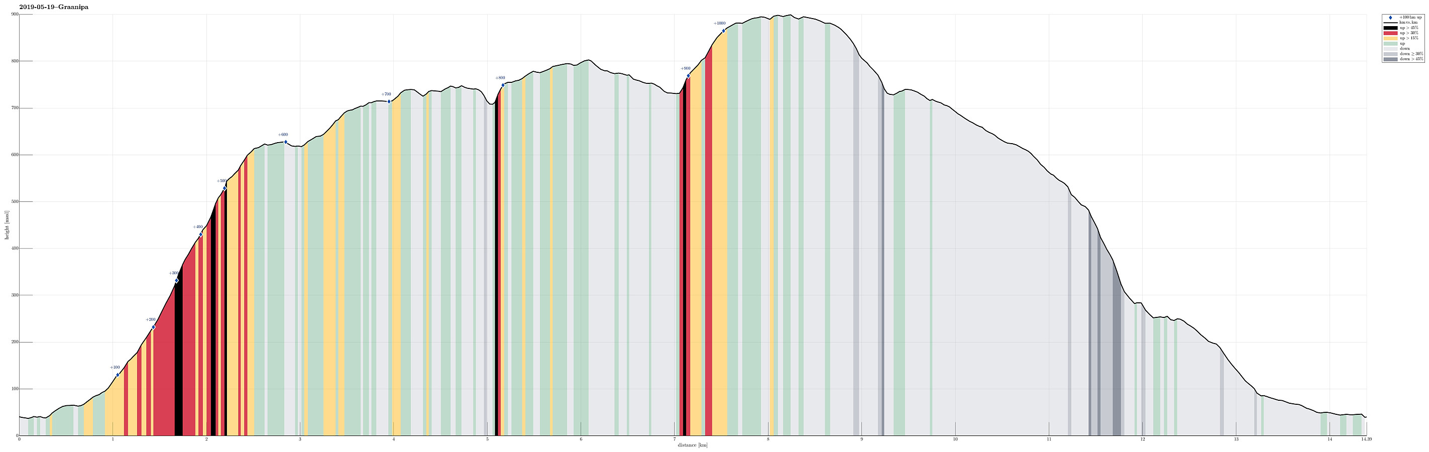
| Distance | 14.4km |
| Vertical meters | 1,091m |
| GPS |
|
| Ascents | Bjørnafjellet (752m) | 19.05.2019 |
|---|---|---|
| Gløvreegga sørvest (902m) | 19.05.2019 | |
| Grånipa (806m) | 19.05.2019 | |
| Javnasåta (636m) | 19.05.2019 | |
| Visits of other PBEs | Kåresteinen (554m) | 19.05.2019 |
Trip Summary
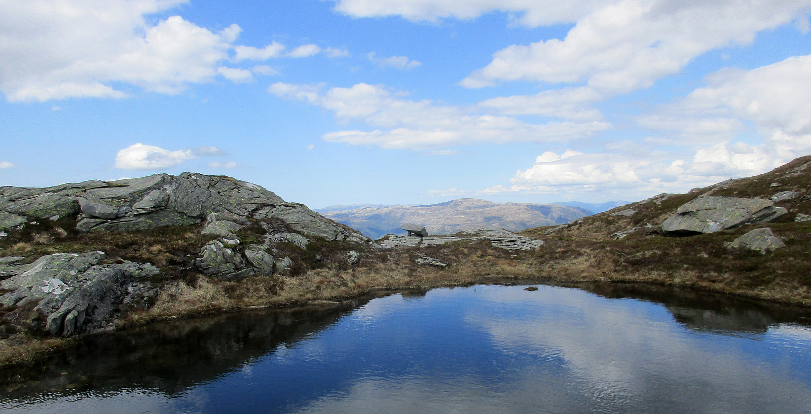
We took the car from Bergen and along E16 into the direction of Voss. At Vaksdal, we left the main road and parked only a few meters away near Vaksdal Senter. From there, we first followed the road a little further down until we crossed over the bridge to the northern part of Vaksdal. There, we followed the roads up to Flordalen. Near the house with address Flordalen 64, a sign marks the start of the trail up to Javnastølen. This trail is well visible all the way up and nice to follow (steep though). Near Lyhornet, one reaches the tree line and nice views over Sørfjorden open up (you need to turn around!). Above Lyhornet, we then followed the high ridge further towards Javnasåta (in northeastern direction). Particularly on this ridge, the views are really very nice! :-) From Javnasåta, then, we could spot a few cabins (at Flærne, a little further north) and followed the trail there. Instead of crossing Hestaskaret right there (further into northeastern direction), we decided to include Bjørnafjellet -- also to catch some additional views down onto Sørfjorden. We thus continued in northern direction from the cabins, turning more into northwestern direction as we got higher. Doing so, we headed (more or less) directly towards the "northwestern edge" of Bjørnafjellet and indeed enjoyed the view from there very much! Next, our plan was to cross Bjørnafjellet in eastern direction (towards Budalen). Passing by several very nice small lakes on the top of Bjørnafjellet, we really liked our decision to include Bjørnafjellet into this hike! Already from studying the map, it was clear that crossing over Budalen is not everywhere possible (it looks as if someone [big] had cut into [deeply] into the mountain with a giant knife!). Fortunately, we found a good opportunity to proceed right away (a bit north in Budalen, but south of Budalsskaret, and into the direction of Jamnasætra, i.e., northeast). Once back up on the heights, again, continuing was nice and enjoyable (not at the least because of the small lakes up there!). After not so long, we stood on the top of Grånipa, looking further east towards Gløvreegga and across Fugletjørna. Also Gløvreegga has its steep sides (particularly also towards Grånipa in its west). We thus looked carefully at the terrain ahead of us to find the best way of getting up there. This lead us first into the upper part of Dyrdalsskaret, where also a marked trail comes up (from Vaksdal, also, but "diagonally" along the mountain side). Even though the trail marks are not so clear and occasionally hard (impossible) to find, we still managed to followed the intended path up to the heights of Gløvreegga. From the higher points of Gløvreegga, we then also enjoyed impressive views to the north: one clearly gets the impression of ancient glaciers having carved off major parts of the mountain there! After considering the time up there, we then decided to turn around and hike back (instead of proceeding all the way to Gløvret). With a bit of back and forth, we descended from Gløvreegga (almost) the same way that we had taken up there. From Dyrdalsskaret, then, we followed this other trail, descending "diagonally" along the mountain side towards Vaksdal (in southwestern direction). This trail heads first to Tjørnhaugen (still high above Sædalen, east of Vaksdal), before it then gets more steeper (and into the forest). But even though the mountain side is very steep there (below Javnasåta), this trail is really a very good one (trivial to find, nice to hike). Southwest of Alsætre, the trail splits (with the upper part leading over to Lyhornet/Javnasåta). Following the descending trail (towards Vaksdal), we then entered a little side-valley (above Sædalen). This brought us down to Sædalsvegen, which we then followed "out" to Vaksdal. All in all, this was a very nice hike in warm and sunny weather -- perfect! :-)
Photos
Selected photos are available as Google photo album.
Useful Resources
See also the related FB-page Hiking around Bergen, Norway.
Web page WestCoastPeaks.com provides useful information about Øyanovi, Møyadalsnubben, Storafjellet, Gløvret, Grånipa, Bjørnafjellet, and Javnasåta.
Web page UT.no from the Norwegian Trekking Association recommends a hike up to Dyrdalskaret (the trail that we took down).

User comments