Knutstignova (return via Harafjellet) (14.04.2019)

| Startsted | Dalseidstølen parking (40moh) |
|---|---|
| Sluttsted | Dalseidstølen parking (40moh) |
| Turtype | Fjelltur |
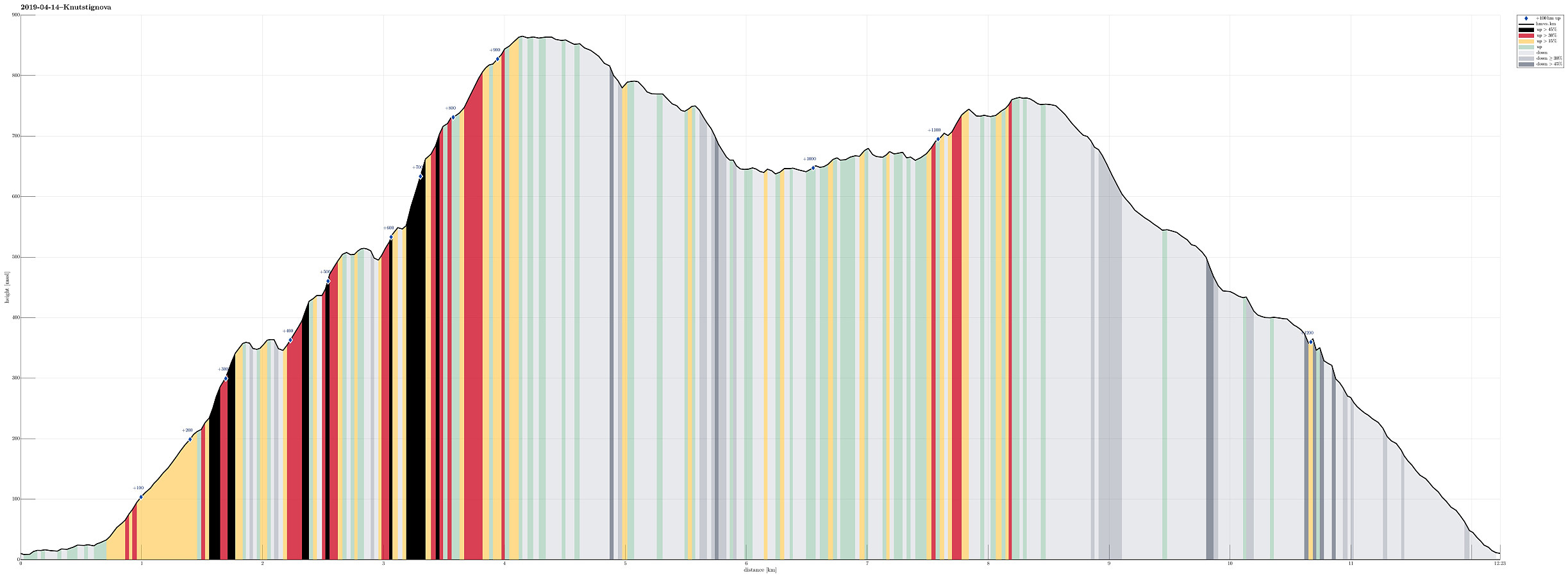
| Turlengde | 6t 00min |
| Distanse | 12,2km |
| Høydemeter | 1211m |
| GPS |
|
| Bestigninger | Harafjellet (764moh) | 14.04.2019 |
|---|---|---|
| Knutstignova (870moh) | 14.04.2019 | |
| Andre besøkte PBE'er | Botnastølen p-lomme (45moh) | 14.04.2019 |
| Dalseidstølen (407moh) | 14.04.2019 | |
| Dalseidstølen p-plass (40moh) | 14.04.2019 |
The combination of hard snow and steep terrain requires special care! We managed well and safely, but thought that it would have been even safer to also pack crampons, this time.
Trip Summary
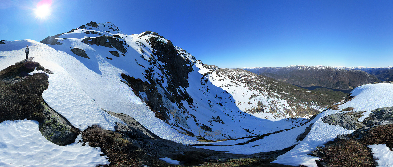
We took the E16 in the direction towards Voss from Bergen and left it (to the left / north) at Dalseid, right after Dale. We then followed the (very narrow!) road along Bolstadfjorden (Kastevika) towards the north until we came to the place where the lower ends of Dalseidmarkåna meet the road. There we parked, expecting that we would come back down here later, and started our hike first with a little more on the road (just around Tretteneset). We continued on the road over the bridge (water that comes down from Straumsmarkåna) and then turned left onto a nice forest road (it does not seem as if anything motorized used that road for a while though). This road/trail lead steeply up through the forest and into the direction of Botnastølen. At about 200mosl, we seemingly lost the trail, which had started to be less clear already a bit further down. Instead of continuing more along the valley, we steadily climbed up (in quite steep terrain) until we found ourselves on a little top (with the power line coming by closely) around which we originally had thought to hike. On the northern side of this little top, it was easy to step down and we continued parallel to the power line. We then recognized that it was significantly steep down to the little stream, which was running parallel to us in the west. Still, it was no problem to find a spot, where we could climb down and cross over it. With this, the more serious part of our ascent to Knutstignova began as we faced more and more snow (mostly hard, which made it easy to walk on, but also increased the risks in steeper terrain). We ascended first towards Rauneteigen, which was pretty OK, even though we did not have any trail to follow there. Actually, there was no real trail to be used/found for several hours onward! :-) From Rauneteigen, we continued towards the southernmost ridge of Knutstignova (in order to avoid the cliffs, which hang high over Rauneteigen at the northeastern side of Knutstignova). We got to a little in-between top, from which we could look over to Kvigedalsegga (impressive view!) across Lompesekken. We then started the ascent over the actual ridge (from about 500mosl upwards). Mostly, at least in the beginning, we were able to use terrain without snow, which clearly eased the ascent over the steep ridge. A bit higher than 650mosl, we then had a critical decision to make: to continue, or to return. Up there, we faced a lot of snow, which occasionally was also hard (very hard). Since the terrain is also quite steep there (and there are large cliffs right underneath), it required a careful consideration. We then gave it a try, beating our shoes into the hard snow (five, six times for each step) to make sure that we would step up safely. This worked (but took a lot of time and quite some efforts, also). At about 750mosl, we had crossed over to a parallel ridge, which appeared to have received more sun and indeed we met softer snow there, which made the ascent much more enjoyable (not thinking about any risks!). Stepping through the soft snow, we arrived at the top of Knutstignova shortly after, enjoying spectacular views from up there! Realizing how much time had passed (about three hours!), we decided to change our plans and dismiss Høgenipa (also this time!). Instead, we adapted our plans to the following: first down to Nedra Krokavatnet (via the saddle to Høganipa), then along Nedra and Øvra Krkavatnet in southern direction, and then via Harafjellet towards Dalseidstølen. We particularly planned to avoid the quite steep northeast ridge of Kvigedalsegga, thinking that it could be too dangerous (hard snow, steep, etc.). With a bit of back and forth, we managed to get down into the saddle between Knutstignova and Høganipa without any major challenges. We then continued over the snow towards Nedra Krokavatnet. Once we had to retreat a bit in order to choose some less steep terrain, but all in all, this descent was without any major challenges, also. Only once or twice, we sank into the there very soft snow deeply, needing to "fight" ourselves out of it again. :-) In the valley, we surrounded Nedra Krokavatnet (on its western side). We then crossed over to the other, eastern side to pass by Øvre Krokavatnet there. At times, the terrain is quite steep there and finding a good way to traverse it is occasionally a little challenge. Still, we manage without too much back and forth. Next was the ascent to Harafjellet. We first reached Dansingahauane, from where we enjoyed some very nice view! From there, it was easy and straight-forward to cross over to Harafjellet. After a last panoramic view (from Harafjellet), we finally started our descent. We first followed some markers into Grøno and were satisfied that the snow was easy to walk on there. Near Slottenova, we left the markers (which lead towards Dale) and continued towards Sæterdalen. We made sure that we would get too low there, but switch over to Dalseidstølen early enough. On one of the smaller tops right over Dalseidstølen, we enjoyed the last rays of sun on this day. And how much sun we had received throughout this amazing hike! We then descended further to Dalseidstølen, rounded Stølsberget, and got into Dalseidmarkåne. There, we found, as expected, the trail, which conveniently leads down towards the street. In the end, we arrived highly satisfied at our car, with a lot of sun in our souls and some strong impressions from a non-trivial hike! :-)
Photos
Selected photos are available as Google photo album.
Useful Resources
See also the related FB-page Hiking around Bergen, Norway.
Web page WestCoastPeaks.com provides useful information about Høgenipa, Knutstignovi, Hestafjellet, Kvigedalseggi, Slåttenovi, Harafjellet, and Nipa.

Kommentarer