Hæddena and Hoklane (12.02.2017)

| Start point | Blom (45m) |
|---|---|
| Endpoint | Blom (45m) |
| Characteristic | Hillwalk |
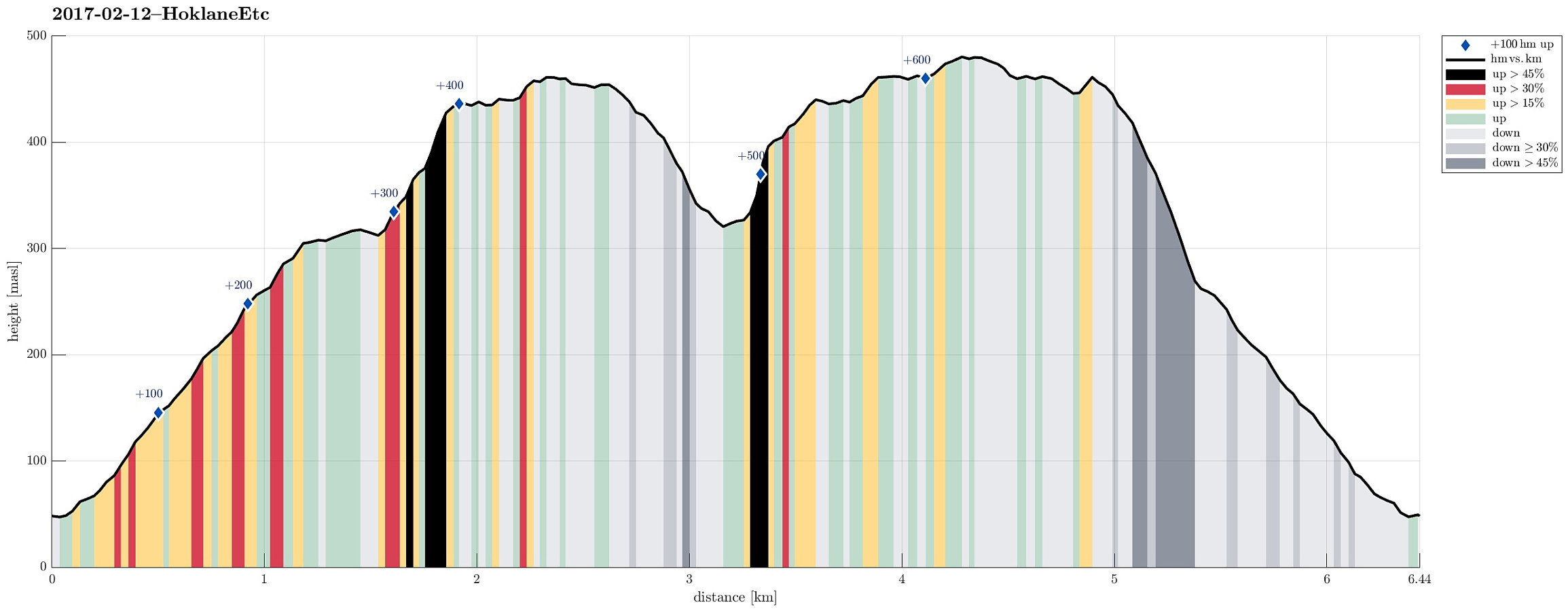
| Duration | 2h 45min |
| Distance | 6.4km |
| Vertical meters | 652m |
| GPS |
|
| Ascents | Hoklane (484m) | 12.02.2017 |
|---|---|---|
| Hæddena (462m) | 12.02.2017 |
Trip Summary
We drove to Arna from Bergen and continued (for a bit) on E16 until we came to the large bridge, which connects Osterøy for drivers. We crossed the bridge and took the first turn to the right (into the direction of Bruvik), instead of entering the long tunnel that leads further inlands and north on Osterøy. We drove this narrow and winding road a little bit to the east until we came to a small place called Blom. There we parked our car along the "main road" (at the eastern end of Blom), after we had asked and checked that this was OK.
Ascending to Blomaskaret
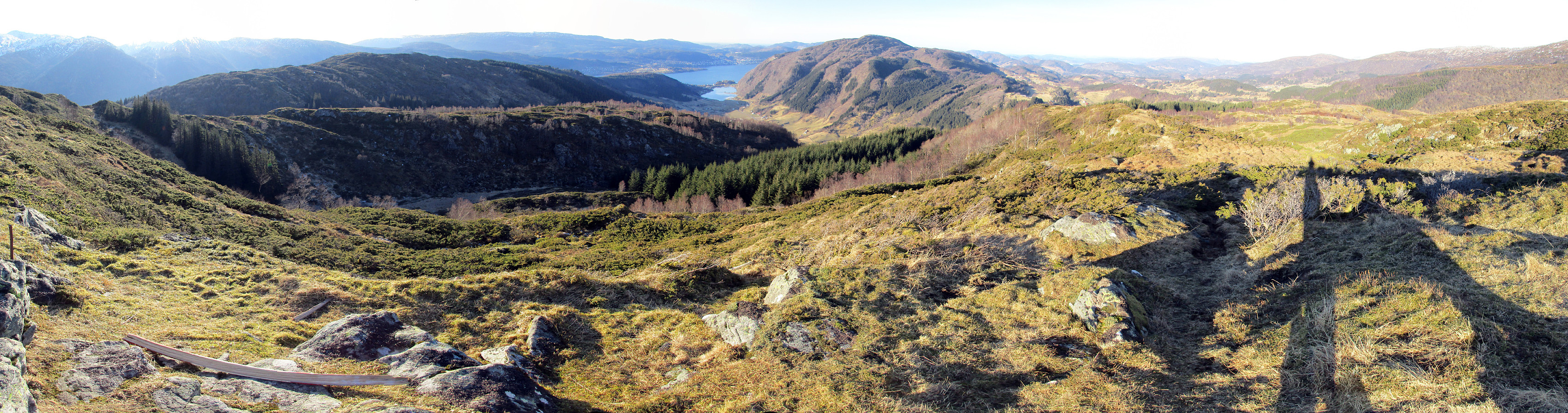
From the car we first walked a few meters back (in northwestern direction), following a narrow secondary road that connects to the few buildings of Blom. Only a few meters up this small road, one can easily find the trail head for this hike (there even is a small map!). The hike continues first in parallel to the "main road" (a bit above it) into eastern direction. After a few meters, again, one needs to get further up to another small trail that is also parallel to the "main road" (next to a small building up there). Once there, the following is easy and convenient: A very nice trail leads up the ridge that comes down from Hoklahaugen quite a bit above. Once one gets up to about 250mosl, the path splits. While a major trail leads to the east (more or less on the same height), another (smaller) one leads further upwards, turning a bit into northwestern direction (and towards Blomaskaret). A bit further up (at about 300mosl) one eventually enters Blomaskaret (its southern end). The map at the trail head recommended to continue further upwards and to the actual saddle of Blomaskaret (before then turning left and upwards to Hæddena), but we decided to try a more direct ascent to Hæddena.
Hæddena
Thus, we turned left once we got up to a comparably flat (and therefore usually also wet) area in Blomaskaret and started to ascend (more or less in western direction now). All in all, it was well possible to get up there (even though it is a bit steep in certain places). At times, we had to fight ourselves a little through some bushes up there. But all in all, this ascent worked very well. Once on the higher grounds (east of the actual "top" of Hæddena), we simply walked over to the "top" of Hæddena, enjoying some nice views already from there. On Hæddena, it isn't fully clear, which of the several "tops" is indeed the highest one (as if this really matters). We also continued a little further (on a small ridge, which extends in northwestern direction of Hæddena) to get some good views of Haus and Stemmeseggi. There, we got impressed by a long stone wall, which comes up to Hæddena from quite far down and then extends further down on the other, northern side of Hæddena.
Over to Stegane
Thinking about which connection to take (over to Hoklane), we decided to follow the stone wall (mostly down and in northern direction). We then used suitable opportunities to get further east (in order to connect to the northwestern end of Blomaskaret). All this worked out well and in relatively short time, we reached a comparably flat (and usually also wet!) area northwest of Vondhaugen. Since Hoklane was our next goal, we aimed at the top of Stegane from there. The southwestern side of Stegane is definitely very steep. We checked (first from below), where we thought that one could get up (without climbing gear). Eventually, we ascended through this steep side of Stegane, knowing that going down there would not be an option, really. Probably, it should also be easier a little further northwest as well as also a bit further to the east.
And to Hoklane
Once on the higher places of Stegane, the continuation towards Hoklane was basically straight-forward (even though not in a straight line). One first walks towards Hoklahaugen (mostly in eastern direction), before then turning left (sharply) and doing the last few meters to the top of Hoklane (mostly in northern direction).
Back to the car
From Hoklane, we first took the same path back, which we had taken up from Hoklahaugen. From the map (at home), we expected to find a nice path that would bring us back down to the ridge, which we had started with in the very beginning. This path, however, seems to not really exist. After trying to find it (within some bushes!), we eventually "gave up" and descended along a fence that stretches downwards in very steep terrain. This brought us down to this major trail, which extends eastwards from the split-point, which we came by in the very beginning. Once there, all the rest was simply walking down the nice path, which we in the beginning had walked up.
Summary
All in all, this hike was really nice. Perfect winter weather and mostly frozen ground made it convenient to proceed, even when there was no path. In a few places, we had to get over some (very) steep terrains, which worked well, but may not be everyone's favorite way of hiking.
Photos
Selected photos are available as Google photo album.
Useful Resources
See also the related FB-page Hiking around Bergen, Norway.
Web page WestCoastPeaks.com provides useful information about Hæddena and Hoklane and also Petter Bjørstad has a useful page about Hæddena as well as another one about Hoklane.

User comments