Nice hike on Vindenes (04.02.2017)

| Startpunkt | Vardhaugen (45m) |
|---|---|
| Endpunkt | Vardhaugen (45m) |
| Tourcharakter | Wanderung |
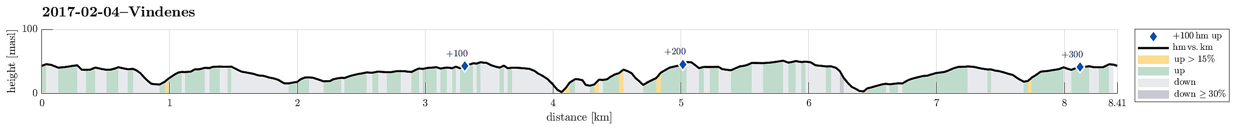
| Tourlänge | 3h 00min |
| Entfernung | 8,4km |
| Höhenmeter | 311m |
| GPS |
|
| Besteigungen | Vindneskvarven (55m) | 04.02.2017 |
|---|---|---|
| Besuche anderer PBE | Nordre Såta (52m) | 04.02.2017 |
Trip Summary
We drove westwards from Bergen, towards Sotra. After passing through the tunnel under Kolltveit, we turned right at the roundabout, continuing on road #561 in northwards direction. We drove through Knappskog to Ågotnes, where we left the main road at a roundabout, which also is the main entry point to the extended business area at Ågotnes, continuing on Bleivassvegen (again northwards) until we reached Vindenes. There we continued (just for very short) a little bit upwards onto the peninsula (to the northeast) until we found a suitable parking place near Vardhaugen (almost where the bus also turns).
Getting started, finding the trail
From there, we walked, following first a smaller road that leads northwards a bit to the west from the road along with we had parked. After only a few meters, we passed by a parking spot (just for cabin owners) and from there on it was then nature only. :-) We first followed a simple farmers road down to the point, where it splits. We first took the one to the left (northwards), which leads up to Vassvikhaugane, but found that one to be particularly wet after only meters. Therefore, we changed our mind, connected back to the one, which extends northwards a bit further to the east, and followed this one further. Shortly before it ends (as a "road"), we found a path, leaving in northern direction to the left, and continued walking on it. Even though not very well visible, this path nonetheless shows up repeatedly, leading down a little ridge towards Kvernavatnet (actually down to a nice "nose"-spot at the southern end of Kvernavatnet with a nice overview of this lake). In order to get back on track, we found a way to descend into the small valley, which separates the ridge on its northwestern side. We then walked back up this small valley (just meters), until we were back on the track, which leads further northwards on Vindenes.
On the main trail, after all
First, we walked northwards next to the small trees, which gather around the uppermost parts of this ridge. Later, we stepped into there to continue on the actual path (well visible and easy to follow). We passed Rundane on our hike northwards and came to a spot near Tytebærhaugen (on our right), where the path splits. We continued northwards on the right (whereas we came back later from the other side).
Herevatnet, Søra and Norda Såta, Kvarvenden
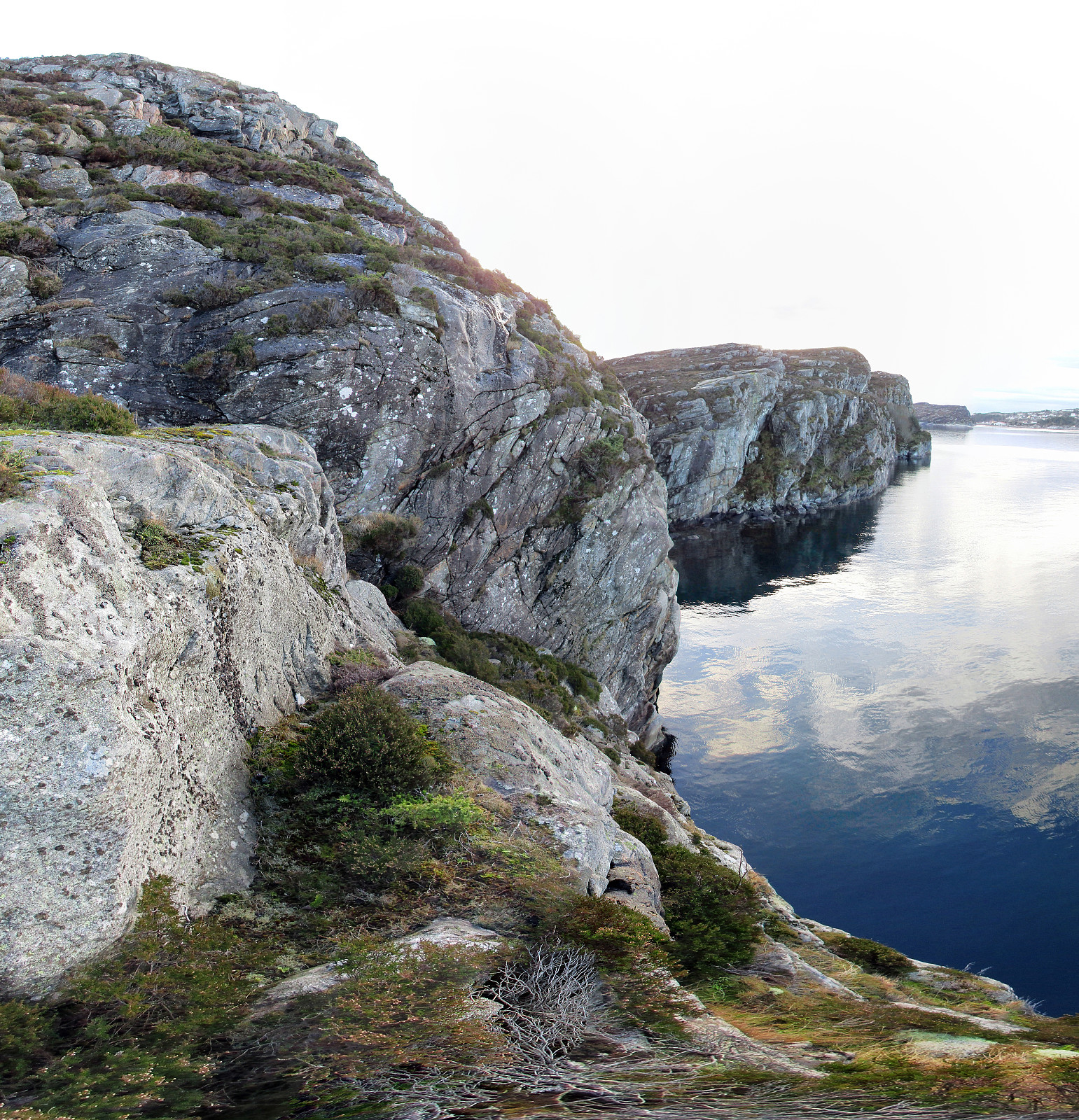
The nice and easy-to-find path leads northwards along the gentle eastern slopes of Vindenes until one comes close Herevatnet, a somewhat magic spot on this peninsula (at least in nice weather). Herevatnet is a lovely small lake on the top of Vindenes and the hiking path leads by it along a somewhat elevated small cliff on its eastern side, offering nice views over this lake. We then continued further north, via Søra Såta (Vindeneskvarven) to Norda Såta, appreciating also the view to Hero (a really very small island just meters to the east of Vindenes). At Nordra Såta, steep cliffs mark a sharp limitation of getting anywhere westwards. Not yet exploring these cliffs in any more detail, we first descended to the very end of Vindenes, Kvarvenden at the northernmost tip.
Challenge: crossing a canyon to the west
We then thought that it would be fun to return on a slightly different "path" and decided that we would try to get to the westernmost cliff of Vindenes, if possible. We first took a half-high diagonal just below the northernmost cliffs on Nordra Såta into southwestern direction until we came to a spot (very near to the canyon, which comes down in northern direction next to the western cliffs of Nordra Såta). There, we did not see any way of continuing safely (one could try to climb up the rocks there, but everything was wet and slippery so we didn't want to risk anything). Thus, we walked back and up to Nordra Såta along the "path", which we had taken down to Kvarvenden. Before reaching the very 'top" of Nordra Såta, however, we saw a promising diagonal, which allowed to descend a bit down to the canyon. The first (upper) diagonal does not really fulfill its promises (ending at vertical cliffs), but the second one (below it) does. So after zigzagging down a bit, we managed to get into the canyon safely (without having to walk south along the upper edge of this cliff for longer). Once in the canyon, the continuation is straight-forward and easy (even though without a path).
Back on the western side of Vindenes
We ascended to Vestre Kvarven (west of Vindeneskvarven) and enjoyed nice views from up there; not at the least southwards and to Herevatnet. We then followed the steep western cliff-side of Vindenes (on its upper ridge) southwards, passing over Kvarven, also. We also found the right location to then depart from the western cliff-edge in order to descend directly to the northernmost bay of Kåsa (down there, it is quite wet; still, it was OK to get down to the bay and over, where one reconnects with the path, which makes it easy to get up to the eastern side of Kåsa and back to the main trail, right west of Tytebærhaugen). From there, we then took the main path back (but without the little detour to Kvernavatnet).
Summary
All in all, this was a very nice hike (in beautiful weather!) on a peninsula, which is mostly just nature and which offers nice views, both to the east (over Hjeltefjorden) and also in other directions.
Photos
Selected photos are available as Google photo album.
Useful Resources
See also the related FB-page Hiking around Bergen, Norway.

Benutzerkommentare