Tørviknuten and Visoldo (04.09.2016)

| Startsted | Åse (175moh) |
|---|---|
| Sluttsted | Åse (175moh) |
| Turtype | Fjelltur |
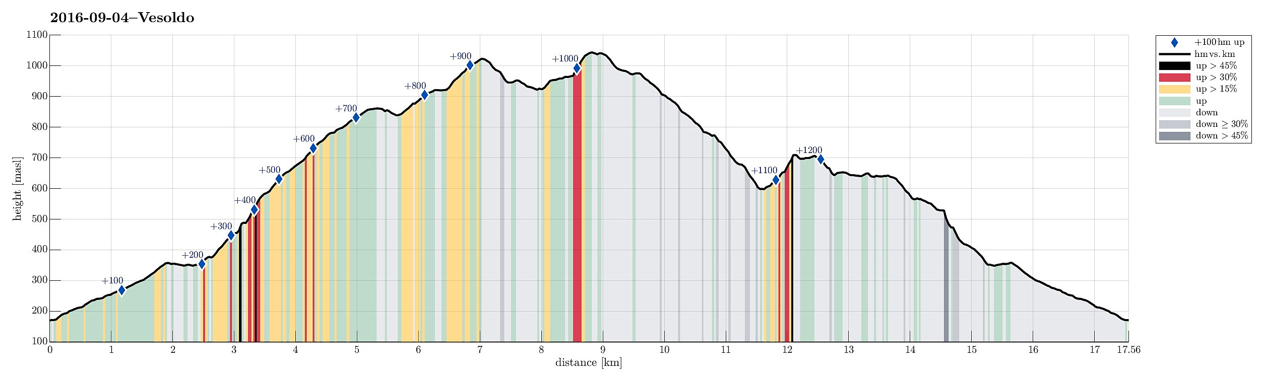
| Turlengde | 6t 30min |
| Distanse | 17,6km |
| Høydemeter | 1254m |
| GPS |
|
| Bestigninger | Tørvikenuten (1028moh) | 04.09.2016 |
|---|---|---|
| Vesoldo (1046moh) | 04.09.2016 | |
| Andre besøkte PBE'er | Foss nær Hågeli (350moh) | 04.09.2016 |
Trip Summary
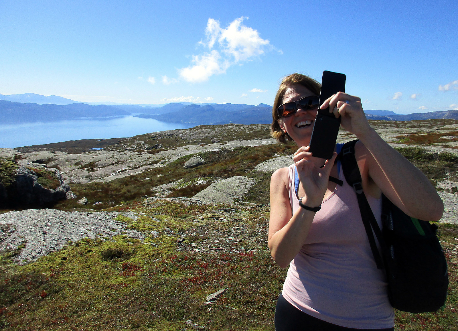
We took FV7 from Bergen towards Hardanger and turned right in Nordheimsund, following road 49 from there. We passed Tørvikbygd and when we had Eidesvatnet to our left, we entered a very small and narrow road, leading up to Åse. We parked a few meters above the farm and started to walk along a forrest road that extends further up from there. As we got higher on this forrest road, we started to pay attention to where a suitable path would take off (to the left and up). When passed Åsstølen (on the right), we started to be particularly curious, but still no inviting opportunity appeared on our left-hand side. Eventually, we decided to walk all the forrest road up (and over a small saddle right west of Hågeli), leading towards a place, where they obivously deal with some sheep, or the like (two buildings). Having reached the end of the forrest road and not having seen any obvious opportunity to get further up (towards Skorsete), we started to explore opportunities a bit more courageously. We first continued a few meters into the direction of the forrest road, passing a gate, crossing a small river, until we ended up before another gate that seemed firmly closed (with some bar nailed across it). This made us turn around there and return to the two buildings. There, we decided to walk the forrest road back a little (basically to the nearby saddle) and then try (without a path) an ascent towards Skorsete. We quickly found something that looked like a "path", used predominantly by sheep. This sheep path lead up in western direction diagonally up (the forrest is quite steep there and stepping along this sheep path was not completely straight forward. Basically south of Skorsete, we ended up underneath some major cliffs right above us (and no really good opportunity to conitnue further west). We made one careful attempt to climb up between some rocks, but decided quickly that this was too dangerous. Instead, we followed the lower end of the cliffs, no in northeastern direction. After a bit, we found a good opportunity to step up and this lead us to the next stage (above the cliffs). Again, we were on a route in western direction---diagonally up, also. After a bit, we turned right, again, into another "valley" that came down from above and which brought us well up to an open area directly underneath Skorsete. There we connected back to the path. From Skorsete, it was then straight-forward up Tørviknuten (some 2-3km from Skorsete). Tørviknuten offers outstanding views over Hardangerfjorden---definitely worth a visit! From Tørviknuten, we continued in northern direction downwards (a bit), turning slightly left (in northwestern direction), finding the saddle between Tørviknuten and Vesoldo. There we crossed over to Vesoldo, which we ascended along a path that leads up there from northeastern direction. Shortly after, we had reached the top of Vesoldo, enjoying further views in all directions! From Vesoldo, we then descended along Hundsryggen in southern direction. While stepping down this ridge, we enjoyed views not only towards Hardangerfjorden, but also towards Tørviknuten and the valley between (Goddalen). Since we aimed back to Skorsete, all in all, we needed to find a suitable connection there (on the map, we had studied this question before and we were optimistic that crossing over just south of Bottsvatnet and across Storafjellet should be fine (which it was, eventually!). In order to get there, we needed to depart from the main path down via Hundsryggen. When approaching Goddalssmettet, we detected a barely visible "path" that promised to lead down to Bottsvatnet, first crossing over a small saddle south of Goddalssmettet. Following this "path" worked out very well and we reached the southwestern end of Bottsvatnet, where the outflow of this lake is, quickly and easily. Crossing over the outflow of Bottsvatnet is not very difficult, even though taking off the hiking boots can be a good idea (no bridge, quite a bit of water). On the other side, we first ascended along a simple ridge in southern direction, before we continued through a small valley further up towards Storafjellet. Once up there, we had new view towards the south (from east to west) and continued (without any path, though) in southeastern direction---basically heding towards Skorsete as directly as possible. While descending diagonally towards the southeast, we came close to Snøfannegjelet and understood quickly that crossing over it would be difficult or impossible (the valley has very steep sides, indeed!). Instead we descended in southern direction west of this valley until we came down to a more flat area, again. From there, it was then easy again to continue in southeastern direction---first heading towards Juvevarden. From Juvevarden, we then continued in mostly eastern direction towards Skorsete. A few valleys have their upper start in this region so hiking more north than south is easier. Shortly after, we connected back to the path that we had take upwards towards Tørviknuten, before. At Skorsete, we then took the path down (instead of descending the same way which we used upwards). This path leads first in northern / northeastern direction (diagonally downwards), before one crosses a simple bridge. Right after the bridge, we turned right (mostly in southern direction, then) and walked down from there. Eventually, we ended up exactly at this extra-closed gate (with the bar nailed over it). So close had we been to connecting to a proper path up, before! :-) From there, we then walked the forrest road down and back to our car at Åse. All in all, one really enjoyed Tørviknuten and Vesoldo---these two mountains offer outstanding views over Hardangerfjorden and also the nature up there is really worth visiting. What a great place, not really far from Bergen!
Photos
Selected photos are available as Google photo album.
Useful Resources
See also the related FB-page Hiking around Bergen, Norway.
Web page WestCoastPeaks.com provides useful information about Vesoldo and also Petter Bjørstad has a useful page about Vesoldo.
Web page UT.no from the Norwegian Trekking Association recommends a similar hike up Tørviknuten.

Kommentarer