Oksen (15.05.2016)

| Start point | Tjoflot parking (235m) |
|---|---|
| Endpoint | Tjoflot parking (235m) |
| Characteristic | Hillwalk |
| Duration | 5h 00min |
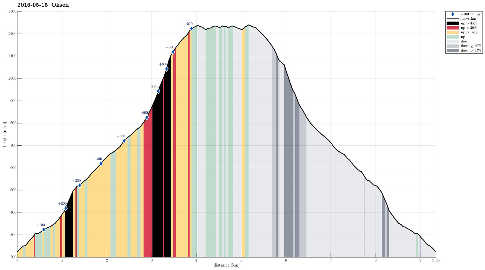
| Distance | 9.3km |
| Vertical meters | 1,066m |
| GPS |
|
| Ascents | Oksen (1,241m) | 15.05.2016 |
|---|---|---|
| Veten på Oksen (1,240m) | 15.05.2016 | |
| Visits of other PBEs | Oksen fra Tjoflot-parkering (235m) | 15.05.2016 |
| Steinsdalsfossen (45m) | 15.05.2016 | |
| Vindhovden (595m) | 15.05.2016 | |
| Vindhovden - Utsikt øst for (780m) | 15.05.2016 |
Trip Summary
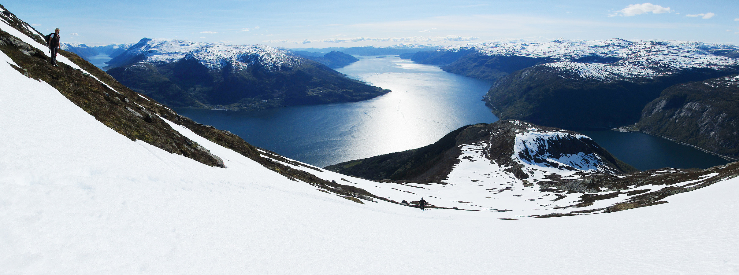
We drove the beautiful road no. 7 into Hardangerfjorden. At Granvin, we connected to the road that comes down from Voss, turning right (into the direction of the new Hardanger-bridge and Ulvik, etc.). We passed the long tunnel (about 8 km), continued towards Ulvik (not up to the bridge) and turned right into a small road right after the tunnel (this place is not completely obvious and paying a little extra attention right after the tunnel helps). From there, we drove (in a way back) all the way out to the tip of the peninsula on which Oksen is the last mountain. The end of the road (and the starting point for hiking) is Tjoflot. There, one can drive a bit up (passing the farms there) and find a parking spot right after entering the forrest. From there (at about 230 meters over the sea level), the hike starts along a forrest road that leads further up (in northwestern direction). The first nice sight over Hardangerfjorden is at a spot, where the trail meets the top end of a steep and high cliff that falls almost vertically into Hardangerfjorden from there. This is also the spot, where another trail (from Hamre) is coming up (from the north). An easy-to-find and nice-to-hike trail leads further up (to a place called Vindhovden). There, right above the tree line, one enjoys great new views over Hardangerfjorden (and the place invites to take a first break, maybe). From Vindhovden, then, the path towards Oksen is clear and almost straight (towards the east and up). One passes by Rindarnuten and continues via Vardane towards Oksen. Mid May, we started to meet increasing amounts of snow about half way up towards Oksen. Since this part of the hike is also quite steep, we decided to pass by the snow as much as possible on our way up (this was quite well possible on the southern edge of this part). Stepping up (over stones and some holes), we came to the place, where the mountain starts to flatten out a little (it's still up from there, but less steep then in the middle). Near the top it was straight-forward and convenient to step over the snow. In order to get the best views, we did not stop at the actual top of Oksen right away, but continued toward a little side-top (almost exactly the same height, anyway), called Veten (towards the south of Oksen). There, we found the wooden platform that someone has built there some time back and it was free of snow, also---how nice is this?! :-) We also enjoyed the wonderful views over Hardangerfjorden, Sørfjorden, and Eidfjorden (with the Hardanger-bridge) from there, before returning. On our way back, we made a short stop at the actual summit of Oksen, before continuing towards Vindhovden. Running down over the snow was fun, but care was recommmended, because of the steep terrain. All in all, we really recommend Oksen as a wonderful hiking opportunity in Hardangerfjorden with spectacular views in all directions!
Photos
Selected photos are available as Google photo album.
Useful Resources
See also the related FB-page Hiking around Bergen, Norway.
Web page WestCoastPeaks.com provides useful information about Oksen and Ingebjørgfjellet
and also Petter Bjørstad has a useful page about Oksen.
Web page UT.no from the Norwegian Trekking Association recommends basically the same hike up and down Oksen.

User comments