Around Toppe via Toppenipa and Geitanuken (06.02.2016)

| Startsted | Toppe (65moh) |
|---|---|
| Sluttsted | Toppe (65moh) |
| Turtype | Fjelltur |
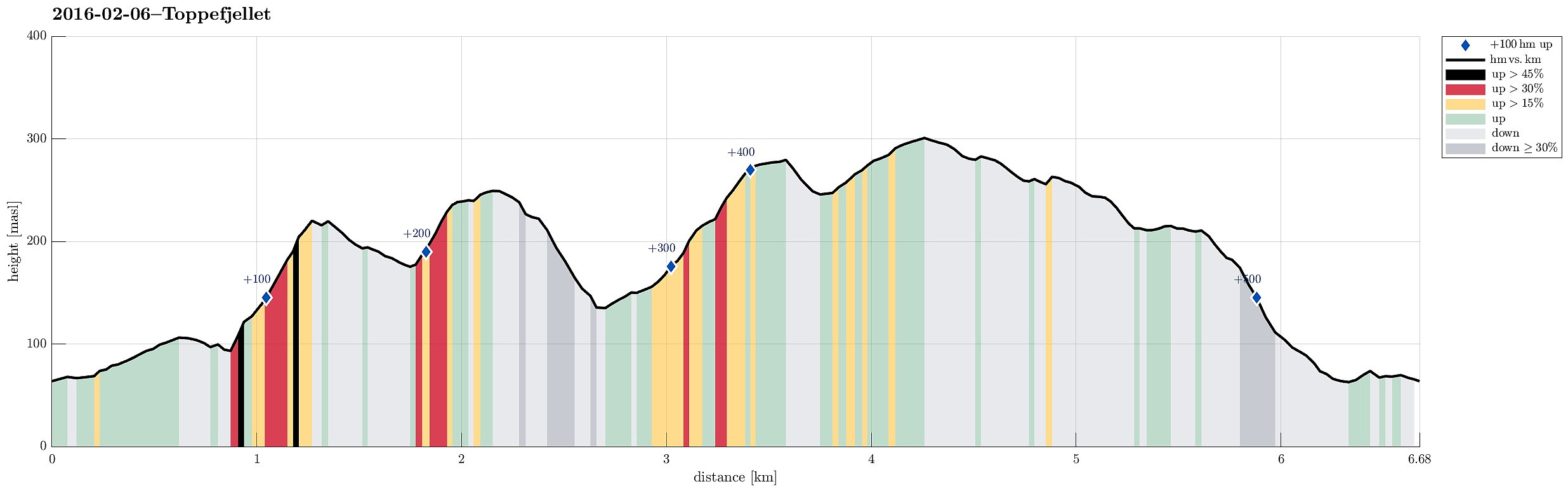
| Turlengde | 2t 15min |
| Distanse | 6,7km |
| Høydemeter | 508m |
| GPS |
|
| Bestigninger | Geitanuken (304moh) | 06.02.2016 |
|---|---|---|
| Novvarden (267moh) | 06.02.2016 | |
| Toppefjellet (253moh) | 06.02.2016 | |
| Toppenipa (232moh) | 06.02.2016 | |
| Andre besøkte PBE'er | Toppenipa parkering (120moh) | 06.02.2016 |
Trip Summary
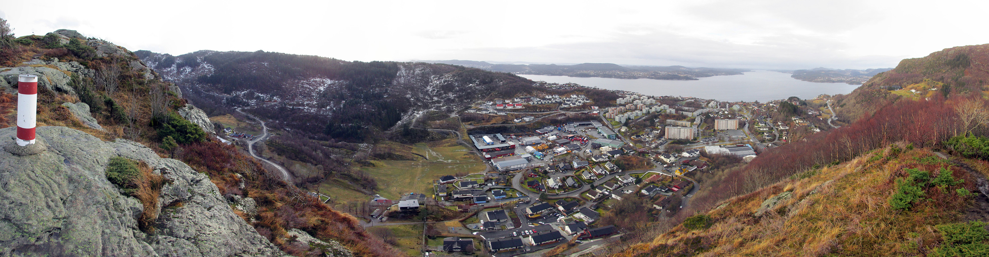
We took the road that leads from Åsane to Salhus and turned left towards Toppe shortly before coming near to Salhus (near Hitland) and passed through a short tunnel right afterwards. Next, we turned left and parked near a commercial area in the middle of Nordre Toppe. From there, we first walked along Toppevegen in northeastern direction until we ended up right above the tunnel that we had taken before (we could have taken a small side-road already earlier, leading directly to the trail head above, but we thought that it only connected to a private house there). Instead we ascended over some green from right above the tunnel and found the trail head also this way, easily. Then we continued upwards towards the top of Toppenipa, following a very nice path that leads upwards steeply. On top of Toppenipa, one already enjoys nice views, towards the west, over Toppe, but also towards the east (Høgstefjellet). From Toppenipa, we continued to Toppefjellet, following a very nice path. Also there, one enjoyes views in different directions (Toppenipa, however, even though a bit lower, is nicer!). We continued further south, descending from Toppefjellet using a fine path, until we came to a crossing spot (you have to look carefully to see it, actually). There we turned right, following the path that came up from the road on the left and crossed our path there towards Toppe (Stølane). We quickly came down into a very wet area, searching for walkable stretched in order to get over to the other side (out plan was not to go back to Toppe right away, but to cross over to Geitanuken via Ulsetvarden). Once we had crossed this wet saddle region, we found ourselves in the middle of a large-scale lumbering area (on the northern side of Ulsetvarden). We continued across newly open stretches upwards, over the rest of cut trees and occasional mud holes, too. The terrain on the northern side of Ulsetvarden is quite rigged and also a bit steep, so getting forward in the desired direction is not easy. Still, we managed to connect to the more western side of this part, ascending there to Ulsetvarden. We came out one ridge further west, actually, than the one the leads to the top of Ulsetvarden, but this was still fine (and probably easier to step upwards). From Ulsetvarden, we continued---again on path! :-)---towards Geitanuken, meeting the main trail upwards there just a few steps before it reaches the top. Since Geitanuken was a side-goal ot this hike, we quickly went there and looked over Byfjorden and towards Bergen. From Geitanuken, it's easy and quick to get back to Toppe via the ridge (Novarinden). Near Vedskaråsen, we turned right, from the ridge, and descended towards Toppe, before getting too close to the houses on the western side. We crossed over to the other, northeastern side of Toppe right behind the commercial area, getting back to Toppevegen and from there back to the car. All in all, it was good to explore Toppenipa (and Toppefjellet)---two hills that do not stand out too much from their surrounding, but that offer nice views and are definitely worth the one or other hike! :-)
Photos
Selected photos are available as Google+ photo album.
Useful Resources
Petter Bjørstad has a useful page about http://www.ii.uib.no/~petter/mountains/100mtn/toppefjellet.html.
Web page FotTurer.com recommends a hike up Toppenipa.
On Bergentopp 200 there is a page (in Norwegian) about Toppenipa.

Kommentarer