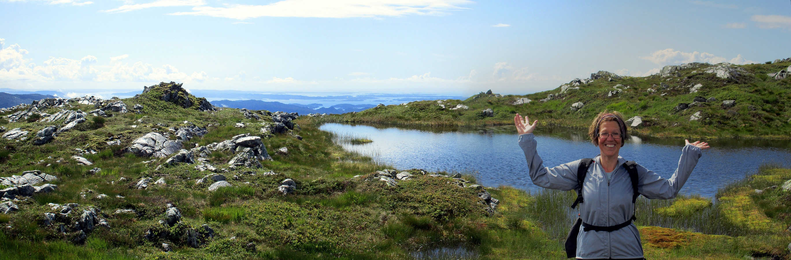
Sveningen from Midseterfjellet (02.08.2015)

| Startpunkt | Øvredalen (45m) |
|---|---|
| Endpunkt | Øvredalen (45m) |
| Tourcharakter | Bergtour |
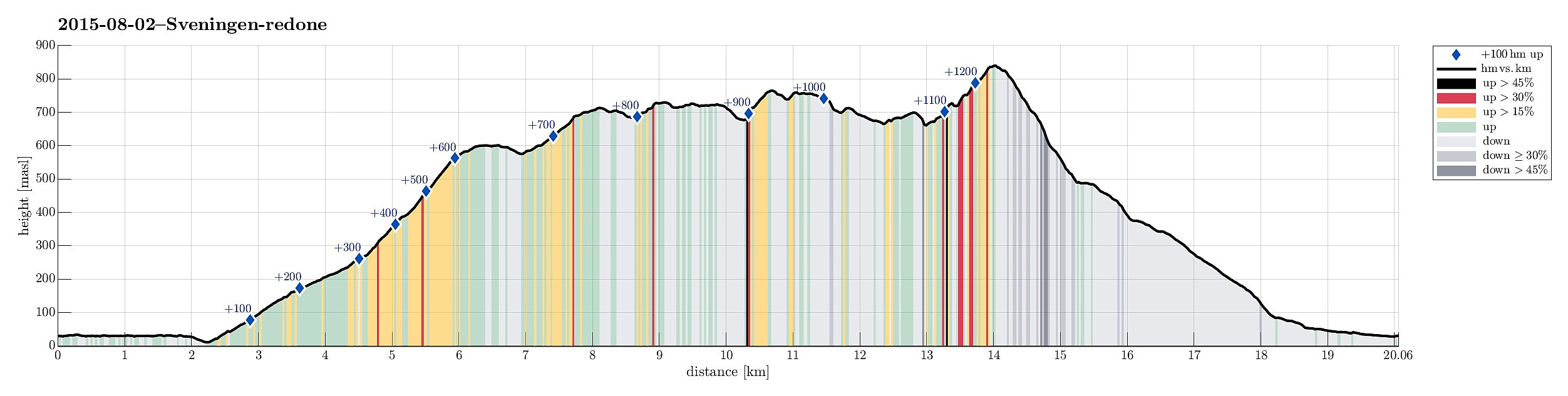
| Tourlänge | 6h 15min |
| Entfernung | 20,1km |
| Höhenmeter | 1.271m |
| GPS |
|
| Besteigungen | Drogegjeltoppen (701m) | 02.08.2015 |
|---|---|---|
| Midseterfjellet (604m) | 02.08.2015 | |
| Rindafjellet (715m) | 02.08.2015 | |
| Sauskolten (732m) | 02.08.2015 | |
| Sveningen (842m) | 02.08.2015 | |
| Søtefjellet (767m) | 02.08.2015 | |
| Søtefjellet NV (762m) | 02.08.2015 | |
| Besuche anderer PBE | Varden på Midseterfjellet (599m) | 02.08.2015 |
| Midsætret p-plass (207m) | 02.08.2015 | |
| Varden på Rindafjellet (690m) | 02.08.2015 | |
| Øvredalen parkering (39m) | 02.08.2015 |
Trip Summary
We parked our car at the end of Øvredalsvatnet (in Øvredalen) and walked back (southwards) along the lake to get to our starting point for the hike over the ridge (in Løyningdalen, right south of where Øvredalesvatnet "ends"). We then walked up the narrow road, which leads up to Midsætret, where a small number of houses assemble. From there, we first followed (for a short stretch, only) a forrest road, which leads mostly westwards, before then taking the hiking path that leads up to Midseterfjellet. First, we hiked in the forrest, but as soon as we left the trees behind, nice views opened, first mostly in western direction. The approximately 15 degrees Celsius were comfortable hiking weather -- in the beginning, however, it rained freshly melted snow, which brought the thought of gloves to us (beginning of August!). Once we got up to Rindafjellet, however, the rain stopped, and really good hiking weather contributed to making this hike a really nice one! From Rindafjellet we continued to Sauskolten and right below the top (on the Sveningen side) we came by a nice little lake (a patch of snow still hanging into it on the southern end). It was simply too tempting to not make a quick jump into that water! :-) From Sauskolten we continuted to Søtefjellet, from which we enjoyed an outstanding overview over Hausdalen. From there, heading towards Sveningen, we came by several additional nice spots (including Langetjørnane, some lengthy water, that strangly splits Søtefjellet into two ridges at the top). The ascent to Sveningen then proved that we had spared the most alpine part for the last top. The path is not everywhere easy to see (between fields of large rocks). Still, it is no problem at all to hike up Sveningen. From Sveningen, we then descended into Øvredalen, via Fjellbotnen and the ridge (in Øvredalen), which separates Skredlievla and Utløelva. At last, we walked back to the car in flat terrain. All in all a long (>6h; ~20km) hike, which definitely is very enjoyable -- mostly, because a very good part of it is high above the tree level with numerous great views in all directions!
Photos
Selected photos are available as Google+ photo album.
Useful Resources
Web page WestCoastPeaks.com provides useful information about Sveningen, Søtefjellet, Sauskolten, Rindafjellet, and Midtsæterfjellet
and also Petter Bjørstad has a useful page about Sveningen.
On web page Fjell og fjas, a very similar tour is described, also.

Benutzerkommentare